01What this actually is
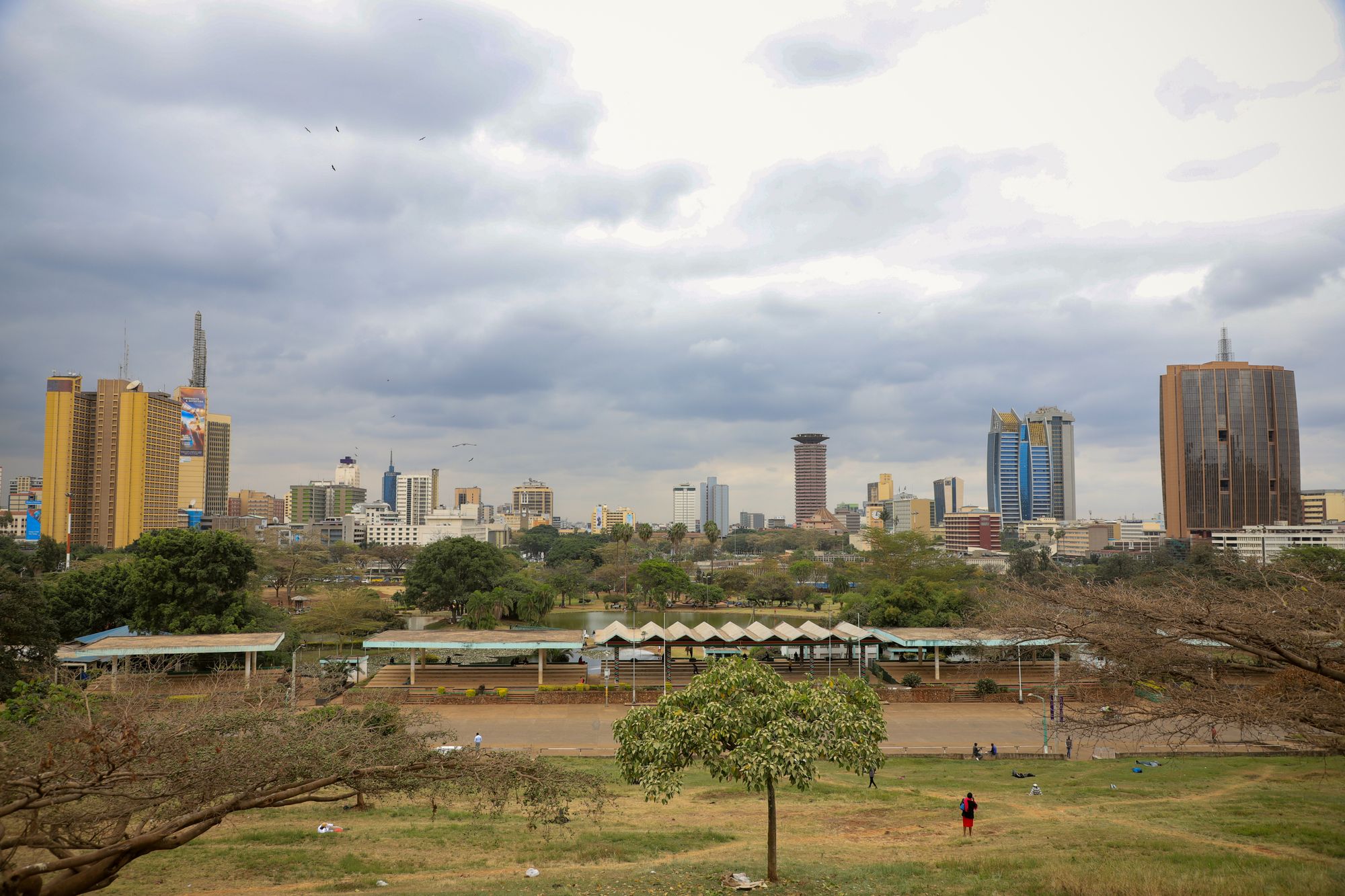
Uhuru Park is the strip of grass, water and paved walk on the western edge of the grid, sitting above Uhuru Highway and holding the towers of the centre up against the sky. It is a public park, entered on foot, and it belongs to the same continuous green edge as Central Park across the road. The reason it earns a page on a site about the CBD is simple: this is the only place in the commercial core where the walking is recreational rather than functional, and the only place the skyline can be seen whole.
What it is not is a quiet garden or a landscaped escape. The lawns are open and used, the paths carry people crossing between the centre and the roads beyond, and the traffic on the highway below runs continuously along one whole side. The lake is artificial, the slope is gentle, and the effect is of a city park in a working city rather than a retreat from one. Come expecting open ground, a view and a sense of where you are in the city, and the park delivers exactly that.
The park also carries a history that shapes how it reads. Freedom Corner at the northern end is where the pro-democracy campaigns of the 1990s gathered, and the park itself was defended against development. Public ground that had to be fought for feels different from ground that was simply provided, and this one is treated accordingly by the city around it. Knowing that before arriving is worth more than any view.
A first visit works best treated as a single unhurried loop rather than a list of sights. Enter from the avenue side, walk the eastern path for the skyline, follow the water, and come out at the north end where Freedom Corner sits. That is the shape of it, and it takes about the time the site lists.
02What there is to see
The park is best understood as four connected pieces rather than one uniform lawn. Each has its own character and its own reason for being on the route, and walking them in order from the eastern path to the northern grove gives the visit a natural shape. The row list below sets out what each is and what to expect from it, so this section deals with how they fit together and how to sequence them rather than repeating the entries.
The water is the centre of gravity. The boating lake is what gives the towers something to stand in, and the eastern bank is where the photograph that everyone associates with this city is taken. Whatever else is cut from a short visit, the lake edge should not be. It is also the busiest part on weekend afternoons, when the boats are out and the photographers gather, and correspondingly quieter at the start and end of the day.
Freedom Corner is the second anchor and the one that requires some preparation. It is a small grove and a plaque rather than a monument you can read at a glance, and its meaning sits in the events that happened there rather than in anything built on the spot. Reading about the campaigns of the 1990s before walking through gives the place its weight; arriving without that context, it can look like nothing much at all.
The KICC view line and Central Park complete the circuit. From the eastern paths the conference tower, the basilica and the bank towers line up in the arrangement that makes the skyline photograph work, and Central Park across the road is the quieter counterpart with the older trees and the monument. Both are worth the extra walking, and together they turn a single viewpoint into a proper route.
The honest sequencing advice is to see the view line first while the light is still doing something, then the water, then finish at Freedom Corner on the way out to the north. Doing it in reverse means walking the political ground in flat light and finishing at the busiest part of the park at its busiest hour, which is the wrong way round.
The boating lake
The artificial lake at the northern end of Uhuru Park, with boats hired on weekends and the towers standing straight up behind the water. The eastern bank gives the cleanest line on the skyline.
Freedom Corner
A small grove and a plaque at the north end of Uhuru Park, where the 1992 hunger strike was held and where the city still gathers. Free, open and unmarked beyond the plaque.
The KICC view line
From the eastern paths the conference tower, the basilica and the bank towers line up in one frame. This is the photograph the park exists to provide, and it works best in late light.
Central Park
Across the road to the north, quieter, with older trees and the Nyayo monument. The two parks are connected, so the walk can be extended without leaving green ground.
03How to reach it from the grid
From the centre of the grid the approach is on foot, and it is short. Kenyatta Avenue runs west from Moi Avenue towards the park, and the distance from that junction to the park edge is just over a kilometre, which the site puts at about a quarter of an hour on foot. That is a straightforward walk along a main avenue with pavements the whole way, and it is the approach almost everyone uses. It also means the park is genuinely part of a day in the CBD rather than a separate trip out of it.
The one thing that needs care is the last stretch. Uhuru Highway runs along the western side of the park, six lanes of fast traffic with no gaps, and it is not a road to cross at street level. The footbridges over it are the only sensible way across, and they are also how you reach Central Park on the far side. Plan the approach so that the bridge is part of the route rather than something discovered at the kerb with the traffic already moving.
Coming from elsewhere in the centre, the park sits at the end of the avenues that run west, so any walk heading that direction naturally arrives at the eastern edge. From the railway station side the route is longer but still on pavements and still walkable. A ride is possible for the last part of the journey, and if you take one, agree the fare before getting in, because the arrangements are set by the operator and this page prints no figure.
The walk itself is level and easy until the last slope down to the lake, and it passes the hotel blocks between the avenue and the park, which is worth noting if the plan is to eat before or after. Arriving on foot at the eastern edge also means arriving at the view line first, which is the right order for the light on a late-afternoon visit.
04Before you go, and the caveat
The practical side of a visit is short, and most of it is about timing. The park follows daylight and closes at dusk, and that rule is enforced rather than nominal, so the visit needs to start early enough that the exit happens before the light goes entirely. Late afternoon is the site's recommendation, and the reason is the light on the skyline rather than anything scheduled in the park. That also means the kiosks and stalls around the paths, which follow the same daylight hours, may be shutting by the time a late arrival wants them, so carry water if the plan runs towards the end of the day.
Everything that moves week to week needs checking rather than assuming. The boating operation is set by the county and changes, so the arrangement that applied on one visit is not a promise for the next; ask at the lake edge what is running that day, and agree anything involving a boat before getting on. Event use of the park closes sections at short notice, which matters if travelling for a specific spot, so the county notices are worth a look beforehand. The bullet list above sets out the rest, and none of it is complicated.
This is the caveat, stated plainly. This page is compiled from published information and the site's own checks rather than from a visit, and it does not print opening arrangements or anything that moves week to week. No opening hour, no closing hour and no boat fare appears here, because the park is run by the county and those arrangements move. Ticket labels such as Free are labels, not prices. Check the closing-at-dusk rule on the day, and rely on what the operator confirms rather than on any figure printed anywhere.
The one part of this that does not move is the political history, and it is the reason the park is on the list at all. That ground was defended, and the campaigns that met there in the 1990s are the reason it is still public. Everything else about a visit is logistics; that part is the substance, and it is worth carrying into the walk.
- Enter on foot from Kenyatta Avenue, and use the footbridges to cross Uhuru Highway: six lanes with no gaps is not a crossing.
- The park closes at dusk and that is enforced, so start early enough to be out before the light goes entirely.
- Kiosks and stalls around the paths follow daylight hours, so carry water if you arrive late in the afternoon.
- The boating operation is set by the county and changes; ask at the lake edge what is running that day.
- Event use of the park closes sections at short notice, so check the county notices before travelling for a specific spot.
What this page does not print
No opening hour, no closing hour and no boat fare is printed here, because the park is run by the county and those arrangements move. Ticket labels such as Free are labels, not prices. Check the closing-at-dusk rule on the day, and agree any boat arrangement at the lake edge before getting on. This site prints no figure the operator has not confirmed.
05Who it suits, and the verdict
This suits anyone who wants the skyline photograph and a proper walk inside a day in the centre. If the plan for the CBD is offices, the avenue and a meal, the park is the one addition that changes the shape of the day rather than adding another stop to it. It also suits anyone interested in the political history, because Freedom Corner is a short walk from the commercial grid and carries more weight than its size suggests. A first visit should go to the lake edge and the view line, then north to Freedom Corner, in that order.
It does not suit anyone expecting a managed attraction with facilities, a set programme or a fixed entry arrangement. There is nothing scheduled here, no guided route, and the ground is ordinary public park rather than a designed visitor experience. Anyone wanting a full afternoon of organised things to do will find the park thin. Anyone unwilling to walk, or wanting to arrive by vehicle directly at a gate, will find the approach less convenient than the distance suggests.
It also does not suit an evening visit. The park closes at dusk and that is enforced, and the site's position is unambiguous: nobody should be in the parks after dark. Anyone planning to be in the centre late should treat the park as a daytime thing and make other arrangements for the evening rather than assuming the gates stay open.
The verdict is that this is worth an hour in the late afternoon, and it is the best-value stop in the centre in the sense that matters: the view costs nothing to look at and the walk is the point. Go for the light, go for the walk, and go with the history read beforehand. Skip it only if the day in the CBD is entirely indoors, and even then the photograph is a short walk away.
Where this page comes from
Desk research, not fieldwork. Nobody writing this stood on the corner with a stopwatch, and a page that implied otherwise would be the least trustworthy thing on the site. The specifics above came from here:
- Uhuru Park: Nairobi City County park information and the reopening notices.
- Uhuru Park: Nairobi City County park information and the published record of the 1989 campaign.
- Freedom Corner: the public record of the 1992 hunger strike.
Opening hours, ticketing and market days change. No hotel or operator pays to appear here.
06Questions
Is it free to enter Uhuru Park?+
The park carries the label Free, and no ticket is bought at a desk. That label is a category, not a price, and this site never prints a figure. Boats, snacks and any event entry are separate arrangements with their own operators.
How long does a visit take?+
One hour covers the lake loop and Freedom Corner at an easy pace. Allow longer if the walk is extended into Central Park across the road, or if the skyline light holds attention. The park closes at dusk, which cuts the available time.
How do you get there from the CBD?+
From Kenyatta Avenue at Moi Avenue it is 1.06 km, about 14 min on foot. The last stretch crosses Uhuru Highway, and the footbridges are the only sensible way over. Do not attempt the lanes directly.
Can you visit after dark?+
No. The park closes at dusk and that is enforced, so it is a daylight visit only. Nobody should be in the parks after dark. Plan to be back on the avenue side before the light goes.
What is Freedom Corner?+
The northern end of Uhuru Park, where the 1992 hunger strike by mothers of political prisoners was held. It is also the ground the campaign against development on the park defended. Read the history before walking through, because the place itself is quiet.