01What it is
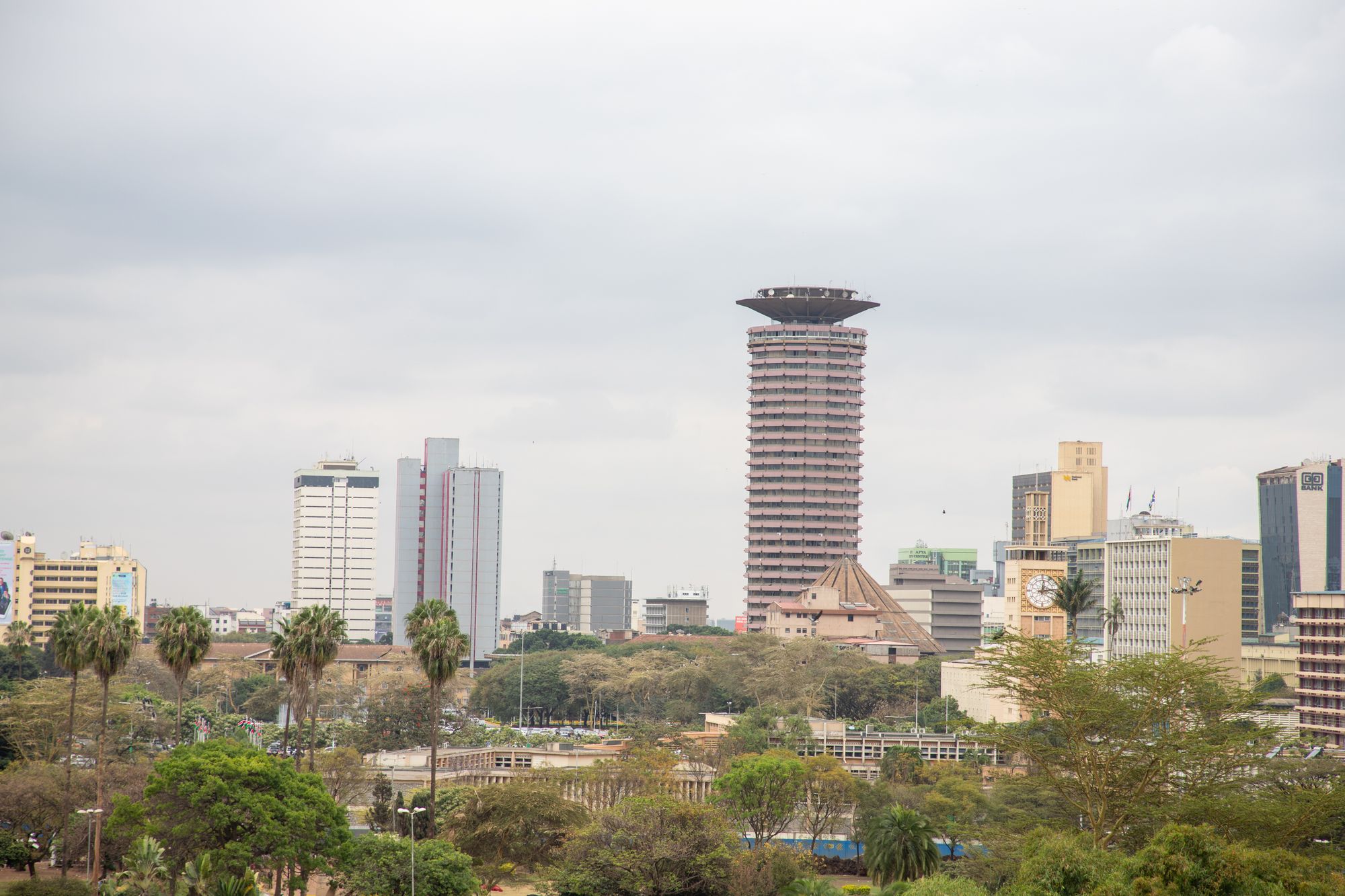
The Kenyatta International Convention Centre was built as the headquarters of the governing party and the country’s main conference venue, finished in 1973 to a design by the Norwegian architect Karl Henrik Nostvik with Kenyan collaborators. It is a cylinder of exposed concrete with a conical amphitheatre at its foot, and for decades it was the tallest building in Kenya and the image on the banknotes.
The part visitors come for is the helipad deck on the roof, which is open to the public with a ticket. There is no glass, no cafe and no interpretation: it is a flat circular platform with a rail, twenty-eight storeys up, in the middle of the city.
02What you can see
North and east
The whole grid laid out: Kenyatta Avenue, the Moi Avenue crowd, the market quarter, and the Ngara edge with Museum Hill rising beyond it.
West
Uhuru Park and Central Park immediately below, the Upper Hill towers on the ridge, and on a clear morning the escarpment behind them.
South
The railway land, the yards, and the plain running down towards the national park.
Straight down
City Square, the basilica, Parliament and the mausoleum, which is the clearest way to understand how deliberately this quarter was arranged.
03Practical
- Tickets are bought at the ground-floor desk inside the building, not online. Identification is asked for.
- The deck can close for weather or for events in the conference centre. Ask at the desk before committing an afternoon to it.
- A lift covers most of the height and a short stair finishes it.
- Morning air is clearer for the long views; late afternoon gives better light on the towers.
- An hour is plenty. There is nothing to do up there except look, which is the point.
One honest caveat
This page cannot tell you today’s ticket arrangement or opening hours, because both are set by the venue and change. Every other guide that prints a figure for them is either quoting an old visit or guessing. Ask at the desk.
04The building beyond the deck
The KICC's cylindrical shaft is not merely a structural choice; it is a statement in exposed concrete that has weathered the tropical sun for half a century. Karl Henrik Nostvik's design, developed with Kenyan architects including David Mutiso, rejected the glass curtain walls then fashionable in favour of a massive, textured surface created by casting concrete against rough boards. That finish catches the light differently at every hour, so the tower changes colour from pale grey to deep shadow without a single pane of glass. The cylinder narrows slightly towards the top, a subtle taper that makes the building feel taller than its storeys alone would suggest.
At the base, the conical amphitheatre roof spreads like a concrete shell over the plenary hall, a shape that echoes the cylinder above while opening the building to the square. This is the part most people pass without noticing, because the entrance canopy and security checks draw the eye. The roof's ribs radiate from a central point, and from the upper floors of nearby buildings the pattern reads as a giant fan. The structure was engineered to span the hall without internal columns, so the space inside can be rearranged for any conference layout, a flexibility that was unusual when it opened.
The materials are almost entirely local: concrete, river sand, and the pale stone that clads the lower podium. There is very little imported marble or brass, which was a deliberate choice to show that a modern national monument could be built from what the country had. The stair cores and lift shafts are expressed on the exterior as vertical fins, breaking the cylinder's smooth curve and giving the facade a rhythm that changes as you walk around it. Even the window openings are set deep into the concrete, so the facade is shaded and self-cooling, a low-tech response to the equatorial sun.
Why does it still read as the image of the city? Because it was the first building here that looked forward rather than back. It did not imitate a colonial club or a bank hall; it invented a form that was unmistakably of its time and place. For decades it was the tallest structure in Kenya, and its silhouette on banknotes and stamps taught a generation what Nairobi looked like. The fact that it remains the shorthand for the capital, long after taller towers have risen on the ridge, is a measure of how completely the design captured something. That is the building's real achievement, not its height.
05How to read the view
From the helipad deck, the city stops being a jumble of streets and becomes a diagram of how the district works. To the north and east, the grid continues with the same regularity you see from ground level, but the deck shows how the blocks step down towards the river and how Moi Avenue cuts a straight line through them. You can trace the matatu routes by the density of roofs and the occasional open yard where vehicles turn. The pattern explains why the pavements are so crowded at certain corners: the buildings themselves funnel people along particular paths, and from above those paths look like rivers.
To the west, Uhuru Park and Central Park appear as two green rectangles stitched onto the edge of the grid, with the boating lake glinting at the northern end. Beyond them, the land falls away towards the ridge and the newer towers cluster along the horizon. On a clear morning the escarpment is visible as a faint blue line, and the deck is the only place in the centre where that distant edge is part of the city's portrait. The parks look smaller from above than they feel on the ground, which is a useful correction if you have been walking them and wondering why they seem so vast.
To the south, the railway lines and the station yard form a hard boundary, a band of tracks and sheds that separates the CBD from the industrial belt beyond. The deck makes it obvious why the centre grew north and west rather than south: the railway was the reason the city exists, but it is also a wall. The train shed roofs are visible in detail, and if a train is moving you can see the whole length of it, something impossible from street level where the embankments hide the tracks. That single view explains a century of urban geography.
Straight down, the paving of City Square is laid out like a carpet, with the basilica and the mausoleum as small models. The scale is the point: from above you can see how the civic buildings are arranged around open space, and how the KICC's own podium connects to the square. This is the view that a street walk cannot give, because at ground level the buildings block each other, and you never see the whole composition at once. The deck turns the district into a map you can read, and after that the streets make more sense. It is worth going up before you walk, if you can.
North and east
The regular grid, the river valley, and the busy Moi Avenue corridor. From above, the street pattern looks like a circuit board, and you can pick out the market and bus stations by their roofs.
West
Uhuru Park, Central Park and the lake, then the ridge with its newer towers. On a clear day the escarpment is a faint line on the horizon, the only natural edge in sight.
South
The railway station and tracks, a sharp boundary that explains why the centre never spread that way. Train movements are visible in full, which never happens from the street.
Straight down
City Square with its civic buildings arranged around open paving. The basilica and mausoleum appear as small models, and the KICC's own podium connects to the square.
06What decides whether the visit works
The single biggest factor is whether the deck is open. It closes without notice for state events, for high wind, or for rain, and the ground-floor desk is the only place that knows. Even if the sky looks fine, a conference booking can shut the roof for the day. That means the visit is never guaranteed, and the sensible approach is to ask at the desk first thing, before you plan anything else around it. If the deck is closed, there is no alternative viewing point in the CBD that comes close, so you either wait for another day or settle for the ground-level walk.
Timing matters more than most guides admit. The air is clearest in the early morning, before the traffic builds and the haze thickens, so the long views to the escarpment are best then. By mid-morning the light is flatter and the distant ridge often disappears. Late afternoon gives warmer light on the towers and dramatic shadows across the grid, but the deck may close before the sun sets, and you will be asked to come down. The middle of the day is the worst of both: harsh light, heat on the concrete, and the least visibility. If you have one chance, go early.
Identification is required, and the ticket is bought at the desk, not online. That is worth repeating because many visitors arrive expecting to book ahead. The lift takes you most of the way, then a short stair finishes the climb. There is no cafe, no shop, no toilets on the deck, and nowhere to sit except the rail. An hour is plenty. If you have mobility concerns, the stair is manageable but narrow, and the deck itself is flat with a handrail. There is no lift to the very top, so a wheelchair user cannot reach the helipad, though the lower viewing areas may be accessible; ask at the desk for the current arrangement.
Who should skip it? Anyone who dislikes heights, because the rail is low and the drop is real. Anyone hoping for a cafe or a leisurely afternoon, because there is nothing to do but look. And anyone who cannot climb a short stair, unless the lower levels satisfy them. But for anyone who wants to understand how the CBD fits together, or who simply wants the photograph that explains Nairobi, the deck is the one thing to do in the centre. Go early, bring your ID, and check at the desk before you count on it.
Where this page comes from
Desk research, not fieldwork. Nobody writing this stood on the corner with a stopwatch, and a page that implied otherwise would be the least trustworthy thing on the site. The specifics above came from here:
- Building history and public access: Kenyatta International Convention Centre visitor information.
- Architectural attribution: published architectural records for the 1973 building.
- Distances: computed from published coordinates.
- Building history and public access: Kenyatta International Convention Centre visitor information.
- Architectural attribution: published architectural records for the 1973 building.
Opening hours, ticketing and market days change. No hotel or operator pays to appear here.
07Questions
Can anyone go up?+
Yes, with a ticket from the ground-floor desk and identification. Access can be suspended for events or weather.
Is it the best view in Nairobi?+
It is the best view of the CBD, which is not the same claim. Nothing else puts the grid, the parks and the ridge in one frame.
How long does it take?+
An hour covers the lift, the deck and the walk back down into the square.
What else is in the same quarter?+
Holy Family Basilica across the square, Parliament and City Hall on the other sides, and Uhuru Park five minutes west.
Can I buy a ticket for the KICC rooftop in advance or online?+
No. Tickets are sold only at the ground-floor desk inside the building, and identification is required. The desk cannot reserve places, so availability depends on whether the deck is open that day. Ask there before planning your visit, because the roof can close for events or weather without notice.
What happens if the rooftop deck is closed when I arrive?+
If the deck is closed, there is no alternative viewing point in the CBD that offers the same panorama. You can ask when it might reopen, but the schedule is not published and can change. The ground-level walk around City Square still gives you the civic buildings, the basilica and the mausoleum, so the trip is not wasted.