01Walking, which is the answer more often than visitors expect
The core of the CBD is roughly a kilometre and a half across. Every distance on this site is computed as a direct line from Kenyatta Avenue at Moi Avenue precisely because, inside the grid, that line is a reasonable guide: the streets run more or less straight, the blocks are short, and the walk is usually faster than the car.
What the straight line does not capture is crossings. Uhuru Highway on the western edge is six lanes and is crossed on footbridges, not at grade. The Globe roundabout in the north has a flyover above it and no comfortable pedestrian line through it. Around Museum Hill the pavement takes a longer route than the road. Add a quarter to any walking figure that crosses one of those three.
02Matatus, and how the system is legible
The matatu network is the city’s actual public transport: privately owned minibuses running fixed routes, each with a number, from stages that are rarely signposted. There is no printed timetable because there are no timetables: a vehicle leaves when it fills.
It is more legible than it looks. Routes have numbers, the numbers are painted on the vehicle, and the crews call the destination. The uncertainty is the fare rather than the route: it is set by the crew and moves with demand, weather and hour, so the thing to do is ask before boarding rather than after. Route data for the whole network has been mapped and published, which is how any app you use knows where the 46 goes.
Boda boda
Motorcycle taxis, everywhere, and much the fastest way through stationary traffic. Also the most exposed: agree the fare first, and a helmet is a reasonable thing to insist on.
Ride hailing
The apps operate across the city and are the default for visitors, particularly after dark. Surge pricing tracks the rush hours exactly.
Commuter rail
Trains run from the old Nairobi station on a small number of lines, mostly at commuter hours. Useful for a specific journey, not for general moving about.
The expressway
A tolled elevated road running roughly along Mombasa Road and Uhuru Highway, with ramps near the ridge. It is why some hotels can quote a short airport transfer and others cannot.
03The two hours that defeat everything
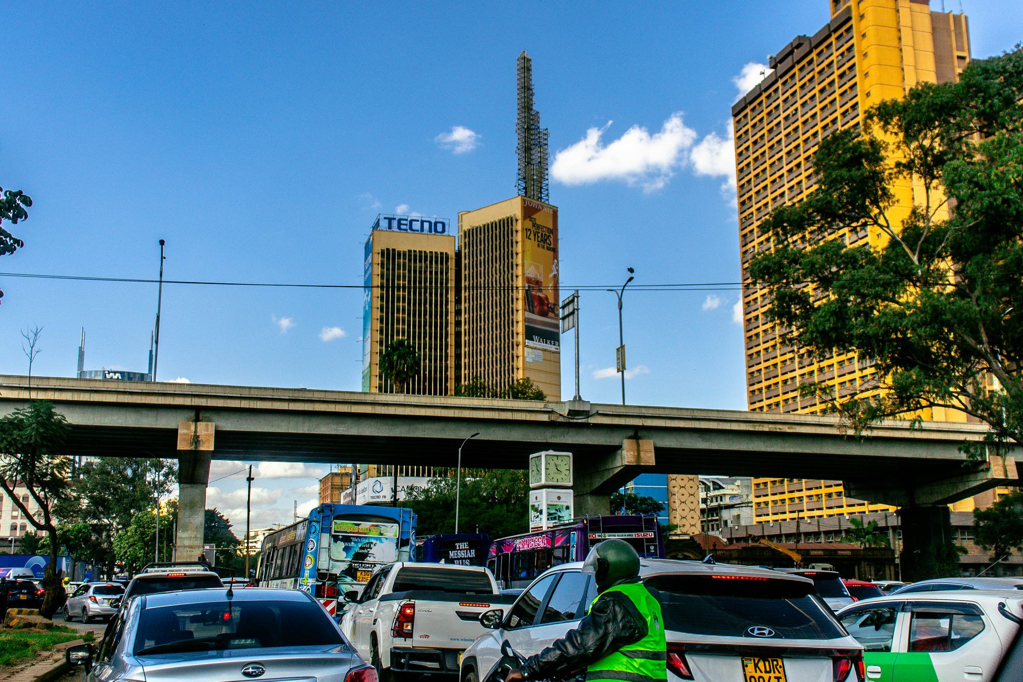
Roughly seven to nine in the morning and five to seven in the evening, the roads into and out of the centre do not move, and no amount of money solves it. Boda riders still get through and pedestrians always do; everything on four wheels does not.
The practical consequence for a visitor is simple. Plan anything that needs a vehicle for the middle of the day, and plan the middle of the day for walking only if you are staying in the grid. A dawn start is worth far more here than in most cities: at six in the morning the centre is empty and the roads are clear.
Times on this site
Walking minutes here are computed from coordinates at 4.8 km/h in a straight line, and the pages say so. They are a floor, not a measurement of your walk: nobody from this site has timed a route for you, and a figure that pretended otherwise would be worth less than the honest one.
04Getting in from outside, and back out
Arriving in the CBD and leaving it are separate problems from crossing it. The two main long-distance entry points sit on the eastern and southern edges of the grid: the country bus termini around Muthurwa, where departures run to much of Kenya, and the old railway station on the southern boundary. Both are a short ride from the avenue and both are working transport hubs rather than visitor facilities. Anyone arriving from the airport comes in on Mombasa Road or down off the expressway and lands on Uhuru Highway at the western end of the centre.
The airport run is the one journey a visitor almost always makes twice. The expressway is the reason it can be quick: a ramp above the grid feeds straight onto the airport road, and on a clear morning the run from the ridge is in a different category from the same run out of the grid. Traffic conditions, not distance, decide it. There are two hours a day when nothing on four wheels moves, and the expressway does not repeal them.
For departures, the practical question is which side of the centre you are leaving from. The country bus termini serve the east and north: buses for Mombasa, for the coast and for the towns beyond Thika load from stands around Muthurwa, and each operator keeps its own office and its own stand. Buy at the office rather than from anyone who approaches you, confirm the departure point on the day, and treat any list of which operator uses which stand as something that moves with each reorganisation.
The railway answers a different set of destinations. Commuter services run from the 1929 station building at the foot of the grid on a timetable the operator sets and revises, so read the current one rather than any guide. Long-distance passenger trains to Mombasa left this station in 2017 and now run from a newer terminus outside the city, which means the old station is a commuter station and a museum piece rather than the place to catch a train to the coast. Check which station your train uses before you set out.
Airport, by expressway
The quick option on a clear morning, with a ramp serving the ridge above the grid. Confirm the pickup point and agree the arrangement before setting off, and treat rush hour as rush hour regardless of the route.
Airport, without the expressway
The Mombasa Road approach, which drops onto Uhuru Highway at the western end of the centre. Slower and far more exposed to the two daily hours when the roads stop moving.
Country buses, eastern edge
Departures for much of Kenya load from the termini around Muthurwa. Each operator keeps its own office and stand, so buy at the office and confirm the departure point on the day.
Trains, southern edge
Commuter services use the old station in the Railway Quarter. Long-distance services moved to a terminus outside the city, so check which station applies before travelling.
05Moving between quarters, not along streets
Inside the centre the question is rarely how to cross one street; it is how to get from one quarter to another. This site computes every distance as a direct line from Kenyatta Avenue at Moi Avenue, and those lines are the honest starting point for a decision. The market quarter, the railway quarter and Ngara all sit inside a kilometre and a half of that origin, which is a walk in the middle of the day. Upper Hill, on the ridge, is nearly two kilometres, which is a walk downhill and a ride back up, particularly once the heat sets in or luggage is involved.
The railway quarter is downhill from the grid and uphill on the way home, which shapes a museum morning. The museum shuts in the mid-afternoon, which conveniently sets the right departure time: go down in the morning and be back on the avenue well before the light goes. Ngara is close but awkward on foot because the Globe roundabout is a road junction with a flyover above it rather than a pedestrian crossing, so the walk to the National Museum up Museum Hill takes longer than the direct line suggests.
River Road is the shortest of the direct lines from the origin and the most demanding quarter to move through. It is walkable from the busy grid in a few minutes and a car through it is slower than walking for most of the day. The grid it belongs to is the eastern half of the centre, which runs on a working rhythm from before dawn to the evening commute. The connection between River Road and Ngara is short and best made in daylight, on Ronald Ngala Street, which is the cleanest crossing point between the two halves.
The choice between walking and riding turns on three things rather than distance alone. Luggage changes a twelve-minute walk into a different proposition. Rain changes any walk into a ride, because the pavements flood at the crossings and the traffic slows at the same moment. Darkness changes it absolutely for the eastern grid: the advice on this site for River Road after dark is flat, and it does not soften because the quarter is close to the origin. Distance is the first question, not the only one.
The grid, on foot
The market quarter, Railway Quarter and Ngara are all within a kilometre and a half of the origin, which is a walk in the middle of the day and a short ride in rain or with bags.
Up to the ridge
Upper Hill is nearly two kilometres and downhill from the centre. Walking down on Haile Selassie Avenue is reasonable in daylight; coming back up after a meeting is where a ride earns its place.
Eastern grid, in and out
River Road is the shortest direct line from the origin and the most demanding quarter to cross. Go in daylight, keep the return leg in daylight too, and take the crossing at Ronald Ngala Street.
Across the northern hinge
Ngara and the Globe roundabout are close but built for vehicles. The walk up Museum Hill follows crossings rather than the shortest line, so allow longer than the straight distance suggests.
06When the usual answer is the wrong one
Rain is the great changer in the centre. The pavements at crossings hold water, the traffic slows in the same hour, and every short walk becomes a ride. The matatu stages work through it as they work through everything, but the fares crews set move with demand and weather, so ask before boarding and expect the answer to differ from the same journey in dry conditions. A boda rider will still get through when nothing else does, and is also the most exposed option when the road surface is poor. The honest position is that a wet afternoon is a good time to be indoors.
Darkness changes the answer quarter by quarter rather than uniformly. The avenue empties with the offices and goes quiet but lit. The railway quarter is industrial and unlit in stretches. River Road is the one place this site says plainly not to be after dark. The ridge is safe and dull, with the hotel bars as the evening and a booked ride to anywhere else. None of those judgements are about distance from the origin; a quarter two minutes away can be the wrong place to be at night and one two kilometres away can be fine.
Luggage tips decisions that are otherwise straightforward. A twelve-minute walk between quarters is a reasonable midday plan with nothing in your hands and a poor one with a suitcase. The railway quarter and the museum are downhill on the way there and uphill on the way back, which is the direction that matters. Anyone arriving from a bus or a train should treat the first movement into the grid as a ride and the rest of the day as a walk, rather than the reverse.
The hours when the sensible choice is not the usual one are predictable. Before dawn the market at Muthurwa and the produce trade around Ngara are running and the grid is empty, so a car down is worth more than at any other hour. The middle of the day belongs to walking. After the offices close, the centre stops being a place to move around in and becomes a place to leave, by a ride that is booked rather than hailed. That rhythm is the single most useful thing to hold on to, and it changes less than the traffic does.
Where this page comes from
Desk research, not fieldwork. Nobody writing this stood on the corner with a stopwatch, and a page that implied otherwise would be the least trustworthy thing on the site. The specifics above came from here:
- Matatu routes and stage locations: Digital Matatus published route data for Nairobi.
- Commuter rail services: Kenya Railways published timetables.
- Expressway ramps and tolling: Nairobi Expressway operator information.
- Commuter and standard gauge services: Kenya Railways published timetables.
- Expressway ramp locations: Nairobi Expressway operator information.
Opening hours, ticketing and market days change. No hotel or operator pays to appear here.
07Questions
Should a visitor use matatus?+
In daylight, on a route you have checked, with small notes and the fare agreed first, it is a perfectly reasonable way to travel and the cheapest by a distance. At night, or with luggage, take a car.
Is the commuter train useful?+
For a few specific journeys at commuter hours, yes. It is not a way to move around the centre, which is walkable anyway.
How long is the airport transfer?+
It depends on the hour and on whether the vehicle uses the expressway. Any single number quoted for it, including by a hotel, is an average of two very different journeys.
Do I need a car in the CBD?+
No, and it is an active disadvantage. Parking is scarce, the traffic is the traffic, and everything in the grid is inside a twenty-minute walk.
Can I walk from the CBD to the National Museum?+
Yes, but the route is longer than the straight distance suggests. The Globe roundabout has a flyover above it and is built for vehicles, so the walk up Museum Hill follows crossings rather than the shortest line. Allow more time than the direct line implies, and come back down into the grid before the light goes.
Is there a train to Mombasa from the old station?+
No. Long-distance passenger services moved to a terminus outside the city in 2017, and the 1929 station now handles commuter services on a timetable the operator sets. Check which station your train uses before setting out, and read the current timetable rather than any guide, including this page.