01Why the skyline moved off the grid
For most of the twentieth century the tall buildings of Nairobi stood inside the grid. The commercial core between Uhuru Highway and the railway held the banks, the insurers and the first office towers, and the height of the city was read from Kenyatta Avenue. That is no longer how the skyline works. The tallest completed buildings in the country now rise on the ridge immediately west of the centre, in Upper Hill, and the grid has been left with the frontage, the pavement and the history rather than the altitude.
The causes are ordinary ones. A plot in the grid is hemmed by streets laid out for a much smaller town, and assembling a large enough site for a modern tower means buying several old buildings and reconciling several titles. The ridge had larger plots, fewer heritage constraints and room to dig parking underneath. Once the first new towers proved that a head office could sit on the ridge and still be five minutes from the centre, the tenants followed, and the skyline followed the tenants west and uphill.
That move is not a decline of the CBD. It is a division of labour. The grid keeps what needs a public address: the bank halls, the civic square, the conference centre and the galleries. The ridge keeps what needs floor plates, parking and a view. For a traveller the practical result is that the centre of Nairobi is now two places a short distance apart, and the skyline you came to see is not entirely above the streets you are walking on.
This page is about the second half of that story. It is about which towers actually define Nairobi as seen from below and from Uhuru Park, and which of them can be given a completion year without guessing. It is not a list of every tall building in the county, and it is not a ranking. It is a reading of the skyline as a visitor meets it, from the pavement and the park, with the record kept honest about what can be dated and what cannot.
02Buildings that carry the change
Start with the cylinder. The Kenyatta International Convention Centre, finished in 1973, is still the building that most people mean when they say Nairobi. It stands on City Square rather than on the ridge, twenty eight storeys of exposed concrete with a conference amphitheatre at its foot and a helipad deck on the roof that the public can stand on. Nothing built since has replaced it as the city's shorthand. Its height has been overtaken; its grip on the image of the place has not.
The ridge towers are the change itself. UAP Tower, completed in 2015, was one of the first of the new generation above the grid, and it remains the building most often cited when the question of the tallest comes up. Other towers on Upper Hill carry the same argument further with floor plates and parking that the grid could not supply, and their silhouettes are what you see from the park when you look west and up. This page dates only the two: 1973 for the KICC and 2015 for UAP Tower. Everything else on the ridge is deliberately left undated here.
The banks on the avenue are the third layer, and they are not towers in the same sense. The head offices along Kenyatta Avenue and its short connectors are mid-century blocks, several with their original banking halls still in use behind the street frontage. They matter to the skyline because they hold the ground line: the avenue is where the city is still legible at eye level, where the pavements are widest and the oldest frontage survives. A skyline is read from the base up, and the avenue is the base.
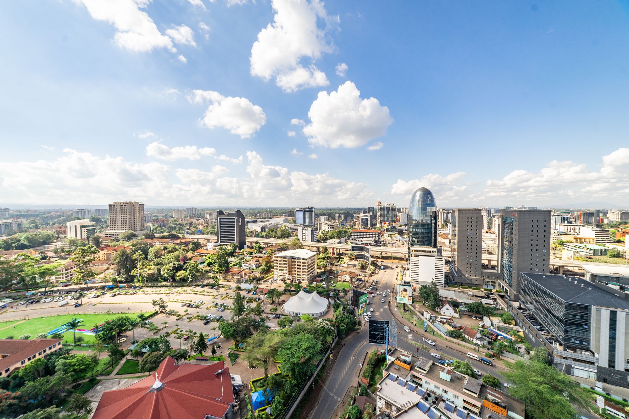
Finally, the park. Uhuru Park gives the one view that no tower interior can give, because it puts the whole western edge in a single frame: the ridge towers standing above the treeline with the grid in front of them. The comparison that matters, between the low historic centre and the new ridge, is only visible from there or from a high floor looking back. The deck at the KICC answers the same question from the other side, looking north and west. Between the two, a visitor can see both halves of the city in an hour.
KICC on the square
The 1973 cylinder in exposed concrete, with the amphitheatre roof and the rooftop deck. It still anchors the civic block and gives the only public view from inside the skyline rather than of it.
The ridge towers
Upper Hill carries the tallest completed buildings in Kenya, and UAP Tower arrived in 2015 as one of the first of them. Office tenants have been moving up there since the 2000s.
Banks on the avenue
Kenyatta Avenue still holds the head offices of most Kenyan banks, so its frontage reads as the older skyline. The height above it has thinned as tenants drift west.
The view from the park
Uhuru Park gives the long view back at the grid and the ridge together. That is where the two skylines separate clearly, and where the move becomes obvious.
03What this page cannot date
The honest half of this page is the record. Completion dates for towers are kept by the developer, the county and the architects, and those three do not always agree. A building can be structurally finished in one year, occupied in the next and formally opened in a third, and any of the three may be the year a website prints. This page therefore uses only the years the handoff already publishes: 1973 for the KICC and 2015 for UAP Tower. Every other tall building on the ridge is left without a date here, on purpose, because a guessed year is worse than no year.
The same caution applies to what moves week to week. Opening arrangements, deck hours and closures are set by the operator and change with state events, weather and maintenance, so nothing of that kind is printed here. This page is compiled from published information and the site's own checks rather than from a visit, and anything that moves week to week is left out. Where a detail matters to your day, the answer is to ask the operator directly, at the desk or by phone, on the day you plan to go.
There is a second gap, and it is a matter of judgement rather than record. Height alone does not make a building define a skyline. A tower can be the tallest thing on the ridge and still be invisible from the park if a neighbour blocks it; a shorter block on the avenue can anchor the whole composition from below. This page is not going to rank buildings by storeys, because the count is not the thing a visitor sees. It is going to say which buildings carry the change, and leave the arithmetic out.
What that means for you is simple. If a date is not given on this page, treat it as unknown rather than as forgotten, and do not carry a year away from here that is not one of the two above. If you need the year for something that matters, ask the developer or the architects, who hold the record. For everything else, the skyline can be read without a single date: the layers are visible, and the two halves of the city are visible, and neither of those facts depends on a year.
- Take the KICC deck for the view north and west, and go in the morning when air is clearer.
- Walk Uhuru Park for the skyline read that no tower interior can give you.
- Use the avenue as the orientation line: it holds the oldest frontage and the widest pavements.
- Ask the operator about deck hours and closures, because state events can shut it without notice.
Completion dates shift
The record of when a tower was finished is kept by the developer, the county and the architects, and those three do not always agree. This page prints only the years the handoff already publishes: 1973 for the KICC and 2015 for UAP Tower. Any other building on the ridge is left undated here, deliberately, because a guessed year would be worse than no year.
04How to read the skyline yourself
Do it in two sittings, and do them in the right order. Take the KICC deck first, for the view north and west over the grid and the ridge. Go in the morning, when the air is clearer, and accept that the deck can close without notice for state events, so ask the operator about hours and closures before you build a day around it. From up there the two halves of the city separate cleanly: the low historic grid in front, the new concrete on the ridge behind it, the park on the western edge.
Then walk Uhuru Park for the reading that no tower interior can give you. From the park you see the skyline whole, edge to edge, with the ridge towers above the treeline and the grid at their feet. It is the one place where the comparison is honest, because it is the same view every photograph of the city has been taken from. Walk the park in daylight, keep to the open ground, and treat the pavements around the edge as the working streets they are.
Use Kenyatta Avenue as your orientation line throughout. It holds the oldest frontage and the widest pavements, and it connects the two things you have come to compare: the civic square with the KICC at one end, and the road west towards the ridge. Once you can place the avenue in your head, the grid arranges itself around it. The ridge is uphill and west; the park is west; the market streets are one block north. The skyline stops being a backdrop and becomes a map.
The verdict of this page is that the skyline is worth one dedicated morning and no more than that, and it should be spent between the deck and the park rather than in any lobby. The buildings that changed the skyline are not, for the most part, buildings you can go inside. They are buildings you look at, from below and from across the park, and the value of the exercise is in seeing the city as two halves rather than one. Do it early, ask before you rely on any opening arrangement, and leave the dates you were not given where they are.
Where this page comes from
Desk research, not fieldwork. Nobody writing this stood on the corner with a stopwatch, and a page that implied otherwise would be the least trustworthy thing on the site. The specifics above came from here:
- Tower completions: published records of the buildings and their completion dates.
- KICC: Kenyatta International Convention Centre, visitor information.
- CBD office relocation: published commercial property research on the ridge and Westlands.
Opening hours, ticketing and market days change. No hotel or operator pays to appear here.
05Questions
Can I go up the KICC?+
The rooftop deck is reached by a lift and a short stair, with tickets handled at the ground-floor desk. Hours move and the deck can close for weather or state events without notice. Ask at the desk on the day rather than trusting any published time.
Which tower is tallest now?+
The tallest completed buildings in Kenya stand on the ridge at Upper Hill, not in the grid. This page does not rank them by height or storey count because those figures change with each new completion. What holds is the direction: new height is built on the ridge.
Why is the skyline drifting away from the CBD?+
Office tenants have been leaving the grid for the ridge since the 2000s, drawn by newer floorplates, parking and an expressway ramp to the airport. The CBD keeps the banks and the older frontage. The ridge keeps the new concrete and the conference floors.
Is there a free place to see the skyline?+
Uhuru Park is open ground on the western edge of the grid and looks back at both the CBD towers and the ridge. It costs nothing to walk in and gives the one view where the two skylines separate. Go in daylight.